Thank you for taking time to visit this post on the Nocoroco Florida historic marker located at Tomoka State Park in Ormond Beach.
If you would like to read other posts on my blog about Florida historic markers, please CLICK HERE.
Text
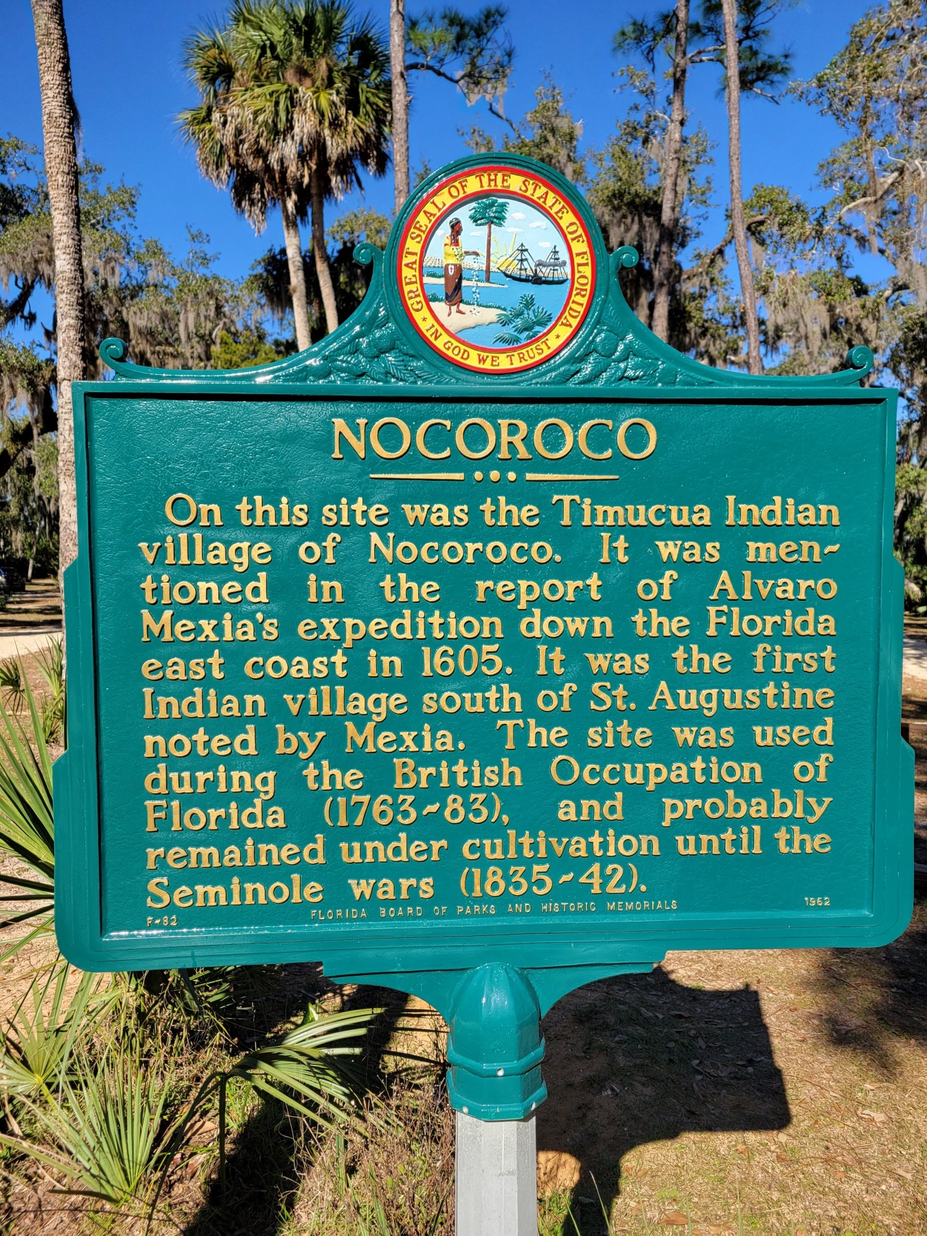
On this site was the Timucua Indian Village of Nocoroco. It was mentioned in the report of Alvaro Mexia’s expedition down the Florida east coast in 1605. It was the first Indian village south of St. Augustine noted by Mexia. The site was used during the British Occupation of Florida (1763-1783), and probably remained under cultivation until the Seminole Wars (1835-1842).
F-82
Florida Board of Parks and Historic Memorials 1962
The Seminole Wars (1835-1842) referenced in the marker also goes by the name, the “Second Seminole War.”
There are three distinct periods of time that claim the moniker of “Seminole War.”
The first is 1817-1818 and led to Spain ceding Florida to the United States.
The second, referenced above, lasted from 1835 until 1842. Because of its length and bloodiness, some historians call the Second Seminole War, The Seminole War. At the conclusion of hostilities, the United States Army transported more than 4,000 Seminoles west. I refer readers to the excellent book written by John K. Mahon titledHistory of the Second Seminole War: 1835-1842.
Historians often call the Third Seminole War, “The Florida War.” The Third Seminole War lasted from 1855-1858.
For readers seeking a good general history of the Seminole Wars, I recommend The Seminole Wars: America’s Longest Indian Conflict, written by John and Mary Lou Missall. This is a readable and digestible look at the conflicts and provides readers a gateway to more advanced works.
Park Admission Information
Tomoka State Park 2099 N. Beach Street Ormond Beach, FL 32174 Park Hours 8:00AM until Sundown 365 days per year Admission: $5 per vehicle (up to 8 passengers) $2 for pedestrians, bikes, extra passengers
For camping information or pavilion rental, please see the websitefor details.
Tomoka is a dog friendly park. Pets are permitted in designated areas and must be kept on a six foot leash. Please clean up after your pet.
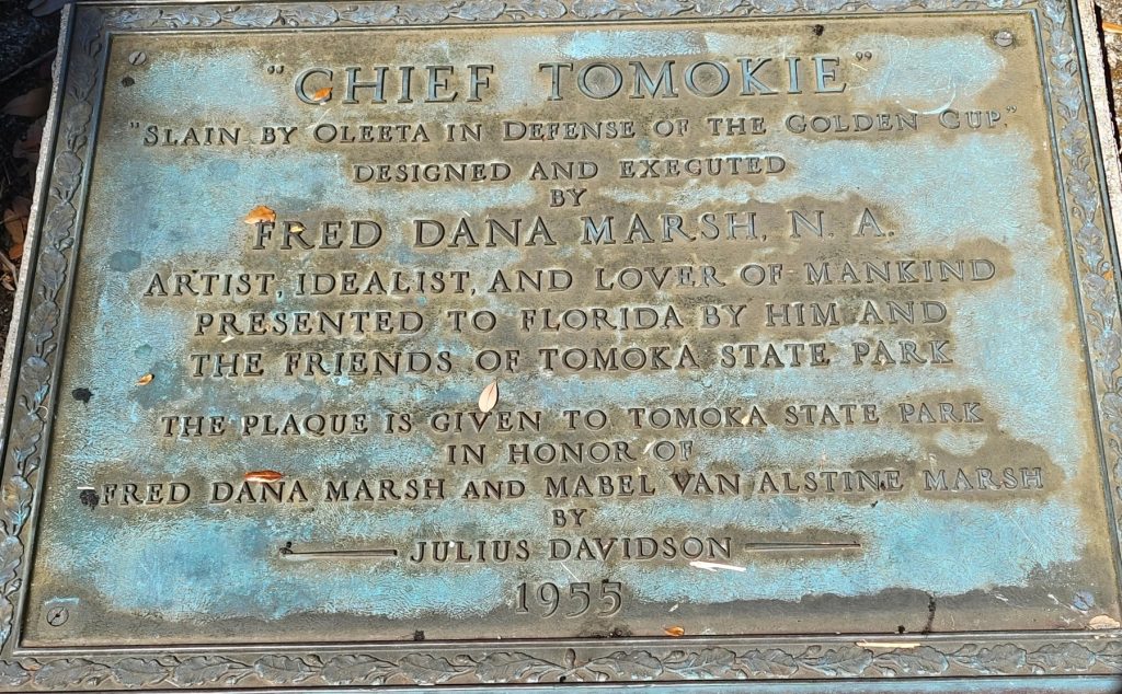
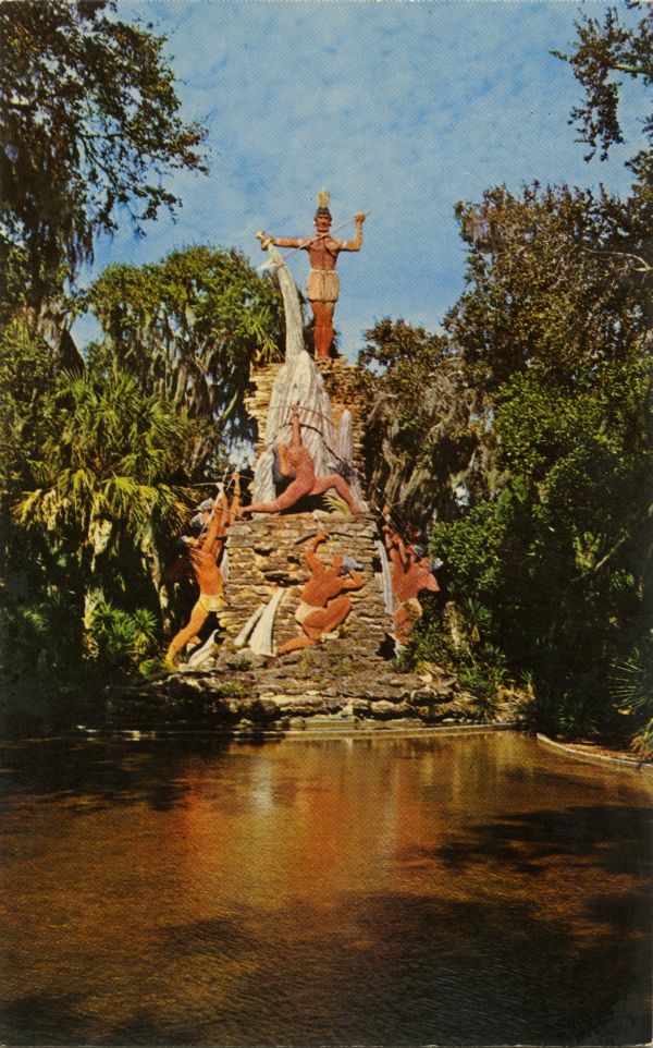
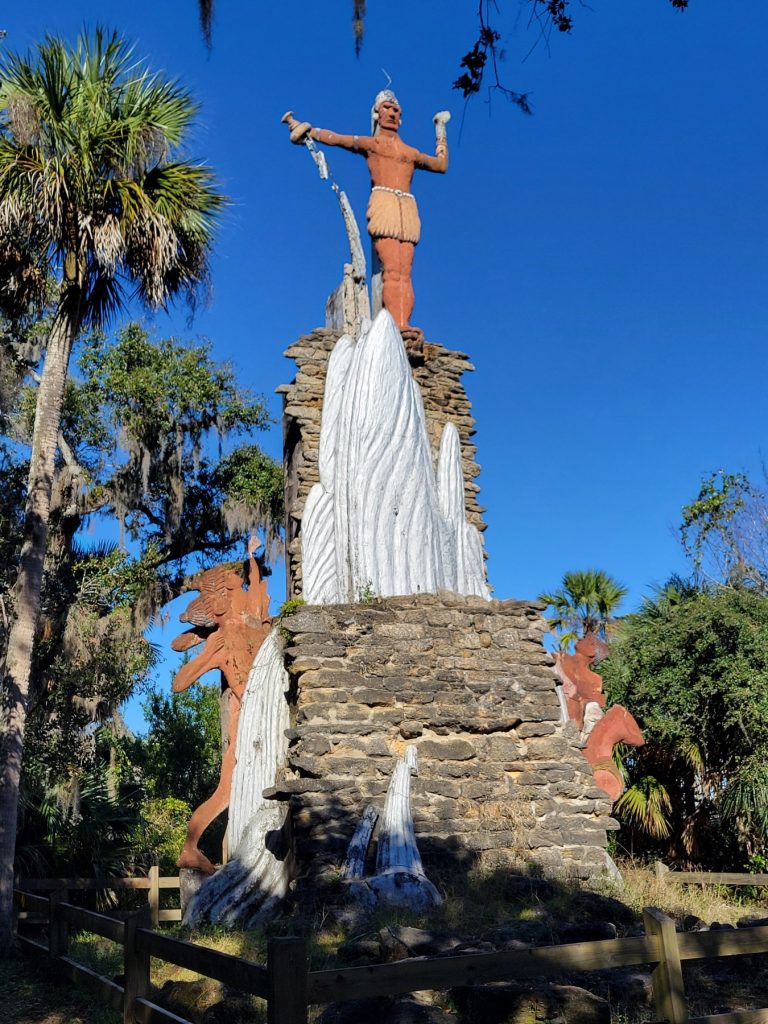
No visit to Tomoka State Park is complete without a visit to The Legend of Chief Tomokie.
Chief Tomokie is a 45 foot tall monument created by artist and architect Fred Dana Marsh that was unveiled to the public on March 21, 1957. Marsh may be best known locally for having created the figures that adorn the Peabody Auditorium and for his home prior to his death, known as “The Battleship.”
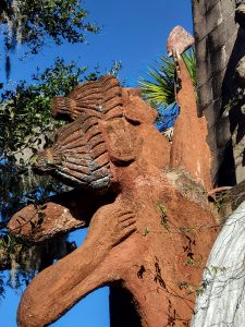
Tomokie depicts a made up Native American legend, concocted by Doris Marie Mann Boyd. Oletta, the warrior princess, is shown aiming an arrow at Chief Tomokie who had dared to drink “the Water of Life from the Sacred Cup.” Tomokie in turn is threatening his assailants with a spear (that has long vanished from the monument.)
The reflecting pool area in front of the monument has been dry since 1974 according to Mark Lane. A museum featuring the work of Fred Dana Marsh opened at the park in 1961 but according to Lane closed in 1996. “The Battleship,” Marsh’s home, so nicknamed because neighbors felt it resembled a battleship when viewed from the road, was demolished with considerable controversy in 1996. The owners claimed the home beyond reasonable repair costs, but ultimately seem to have had no plan to build there and sold the property in multiple lots. Marsh’s home was located at 317 N. Ocean Shore Boulevard in Ormond Beach.
Tomokie Today
Today, The Legend of Chief Tomokie is in considerable disrepair despite several organized attempts to raise funds for restoration. Governor Jeb Bush vetoed state funding of $100,000 in 1999 despite local political support.
The monument, originally constructed from cement, brick dust, and bamboo rods, is still a favorite of visitors who marvel at the size and wonder if the legend could be true.
Artist Fred Dana Marsh was born April 6, 1872 and passed away on December 20, 1961.
Marker dedicated to Fred Dana Marsh, in front of what used to be a reflecting pool at the Chief Tomokie monument.
Find the 30 best things to do in Daytona Beach in my blog post HERE.
Sources
Davidson, Herbert, editorial. “The Meaning of a Statue.” Daytona Beach News Journal. March 23, 1957.
Egan, Bill. “Marsh’s Influence Still Lives in Work.” Daytona Beach News Journal. April 21, 1996.
“Fred Dana Marsh is Dead at 89.” Daytona Beach News Journal. December 21, 1961.
Gear, Barry. “Battleship Sails Into Memories, Onto Video.” Daytona Beach News Journal. May 20, 1996.
Griffin, John W. “Nocoroco, a Timucua Village of 1605.” Florida Historical Quarterly. Volume 27: No. 4. 1948.
Lane, Mark. “Curious Coast: What is that Statue at Tomoka State Park?” Daytona Beach News Journal. July 8, 2018.
This post may contain affiliate links.As an Amazon Associate, I earn from qualifying purchases. If you click these links and make a purchase, I may receive a small commission. This commission does not affect any price that you pay. Affiliate programs or sponsors providing products do not influence views and opinions provided in my blog.
Thank you for reading. Here you will find the 30 Best Things to do in Daytona Beach, Florida. Whether you are a visitor, a local, or a day tripper, there are many things that the entire family will enjoy. There are no chain locations or food listings. This list is meant to promote locally based attractions and shops. These are places you won’t find in every community or tourist destination. So jump in, and review the 30 best things to do in Daytona Beach, Florida.
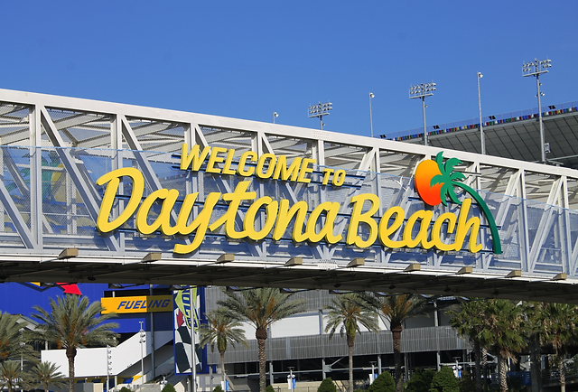
Welcome to Daytona Beach. Image courtesy Volusia County Properties
DAYTONA BEACH
Known as the World’s Most Famous Beach or the home to the World Center of Racing, Daytona Beach has often staked its reputation and future on these two industries. The beach and the speedway are two things that are not going anywhere. They are the rock on which Daytona’s tourism future still stands. Daytona Beach is much more than the beach and NASCAR however. In fact, here are the 30 best things to do in Daytona Beach, Florida.
Yes, there is bike week and Biketoberfest. But, in speaking with longtime observers these events aren’t quite what they used to be. Sure, they bring people to town but the fact is, this is an aging market. It’s a market that has moved outward. This includes as Destination Daytona in Ormond Beach rather than the older hangouts in Daytona. Other cities within easy driving distance are also siphoning off visitors. In addition, bike events are held around the country. It’s not the novelty it used to be. Almost every tourist mecca has these events so Daytona doesn’t have the uniqueness it did many years ago. Bike Week isn’t going anywhere but I am not sure Daytona Beach should stake its name on the event.
Events come and go. Take spring break. Compared to the heydays’, spring break is almost a non-event today. Black College Reunion? The same thing. Today, in addition to the pop-up truck and jeep events that nobody in town other than hoteliers is interested in, the Welcome to Rockville, multi-day heavy metal concert is one of the biggest annual events. Of course, promoters can take their ball and go home any time they feel unloved or that they can get something better out of another town. I don’t foresee this being an event Daytona will hold on to long term without committing public funds. Local businesses seem to love this event and many claim it is their most profitable special event during the year.
A concern many event attenders voice about Daytona are accommodations. Many buildings have been damaged by hurricanes and have not reopened. Those that are in business are charging what these visitors consider exorbitant rates. It’s not my place to say whether that’s true or not but visitor actions speak loudly.
And while Daytona Beach often has an identity problem, compounded by multiple groups trying to promote and support tourism, don’t be scared away by the revolving door of publicity campaigns or the negativity about some of the seedier areas of the community. Pay attention to your surroundings, use common sense, and just like in any other city, you’ll be fine and have a good time.
TRAFFIC
Daytona Beach can run the gamut on traffic congestion.
I have been beach side when there is very little traffic. Mind you, that is during off season and during the work week. International Speedway Boulevard from say, Clyde Morris Boulevard to Beach Street is usually pretty busy no matter the time of year. In the vicinity you have a large high school and two colleges, in addition to ISB being a major thoroughfare to beach side. Congestion is inevitable.
During peak season, say March through August/September back to school, weekend driving can be pretty harsh in spots. If you are coming to town during one of the weeks there are races at the speedway, be prepared for major headaches on International Speedway Boulevard and the highways that funnel onto the road. Pay close attention to any of the temporary electronic billboards on the side of the road and keep an eye out for pedestrians, who often don’t think crosswalks apply to them.
During bike week events in March and October, be on the lookout. Traffic can be busy, especially near the Main Street and Destination Daytona areas. Bikers are notorious for riding in wide and deep packs with many not paying attention to larger vehicles. Bikers weaving in an out of traffic is common and making extra lanes is commonplace.
Spring break and certain truck, jeep, and other pop-up events, sanctioned and unsanctioned, can tie up beach side traffic to a point it is at a stop. Many of these people see a need to cruise slowly up and down A1A, causing gridlock on the narrow and heavily stop lighted A1A.
Summer traffic during the weekends can be heavy as the beach is a popular, low-cost way for people to spend the day. Beach entrances are limited and it just takes time to get cars through the toll booths. Just be patient or scout ahead and find some of the off-beach parking lots.
While we are on the topic of traffic, city leaders have a mind that there must always be some type of road construction going on. This is not usually fixing potholes and the like, but rather, some type of project meant to enhance the city image while usually tying up traffic for long periods and often not having the anticipated outcomes. Just shake your head and drive on. The project will be complete in two years when another will be started.
Google maps and a bit of patience are your friends and will get you around the Daytona Beach area.
WEATHER
The weather in Daytona Beach can be brutal during the summer months. Don’t let the online historical records tell you otherwise. Weather report numbers are recorded at Daytona Beach International Airport and may not be accurate throughout the area.
The NOAA states that from 1991 through 2020 the average high for the year is 80.6 with a low of 62.5. They claim the average high in July is 90.2 and in August is only 89.8. I strongly believe most locals would challenge these numbers as being too low. Daytona Beach is HOT, there is no way around it. Try shorts and t-shirts on Christmas many years hot.
When it comes to precipitation, be prepared, especially if visiting during late spring through the summer months. Violent thunderstorms can come on rapidly and if you are on the beach, lifeguards will be working to safely clear you out. Getting a packed beach safely cleared is an undertaking but the lifeguards to a fine job. The NOAA states Daytona Beach receives an average of 51.25 inches of rain and 119 rainy days per year.
A word on hurricanes and tropical storms. Don’t be the tough guy trying to brave out a storm beach side. If you are in town and there are evacuation notices issued, pay attention. If you are staying beach side, please remember that bridges are locked down after winds reach a sustained 40 mph. You won’t be able to change your mind and leave and EMS will probably not be able to reach you if something bad happens. It’s rare, but keep a watch on the weather if you are visiting during hurricane season.
Here’s a personal story about Daytona Beach weather. I have been to exactly one NASCAR race at DIS. When I worked in trade books, a couple of book reps were in town for February races and had extra tickets and very generously invited me to attend. This was the Saturday race so the grandstands were not full. We were wrapped in coats and freezing. The temperatures were kind of low and the wind was very strong through the grandstands. Despite the cold, the sun was so strong we all left with sunburned faces and necks.
WHAT TO SEE AND DO IN DAYTONA BEACH
So, you are thinking of visiting Daytona Beach. Maybe you are already in town on vacation and are looking for things to do. Well, here is a list of 30 best things do in Daytona Beach or local activities you should consider. I have provided hyperlinks to official websites or sites with considerable information. It is recommended you check these sites to confirm open hours and associated costs.
What you will not find on this listing are things such as shopping malls, bars, and restaurants. There may be these type activities associated with a few of the items listed but you can find a shopping mall on your own. Chain restaurants, which proliferate in Daytona Beach, can be found on almost any interstate exit. There is nothing unique or interesting about these places and their Daytona Beach franchises are no different. I strongly urge you to seek out local restaurants, bars, coffee shops, and stores. Daytona has a lot of unique opportunities for you to try.
A word about using this list before you start. Many of these locations begin with the name Daytona or Daytona Beach. It can be easy to overlook this part of the listing but you will not want to miss some of these places.
This listing is alphabetical and not in order of favorites or by category. This list includes locations from Ormond Beach to the north through Port Orange and Ponce Inlet to the south. .
Finally, this list is by no means all inclusive. What are some of your favorites that I have not included? Drop me a line or leave a comment. Do you own or work at a destination I didn’t include? Let me know. Maybe I will update it to 31 things to do. Did you not enjoy one of the places I have listed. Leave a constructive comment and I will approve it for posting.
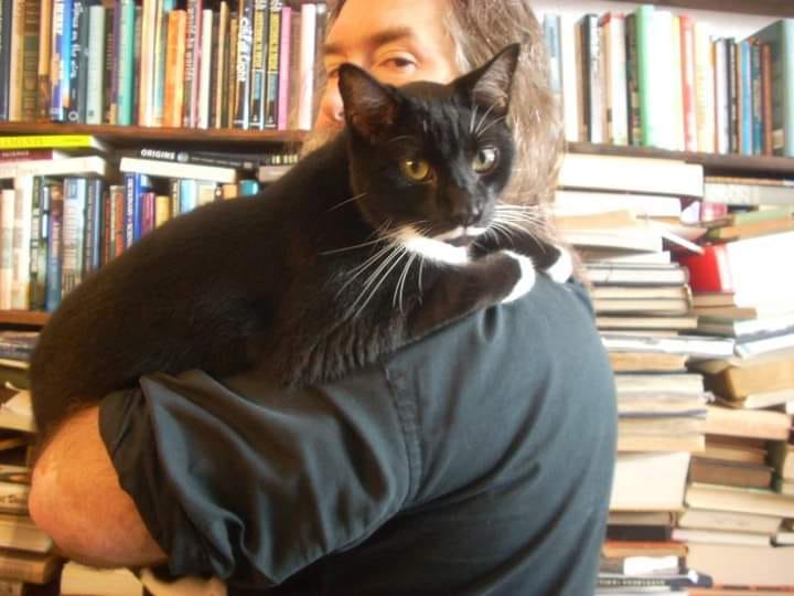
Are you looking for that hard to find title, or maybe something to help pass the time while lying in the sun at the beach? With well over 100,000 titles in stock, Abraxas Books is the place to go.
For full disclosure, I have known Jim, the owner, professionally for well over twenty years. I have purchased hundreds of books from him. He know his books.
Abraxas Books owner Jim Sass and the world famous bookstore cat Sterling. Image courtesy Abraxas Books.
A few words of advice you should heed. Jim loves cats. He enjoys dogs, but cats are the way to go. You are not likely to find James Patterson, John Grisham, or other exceedingly popular mainstream fiction authors on the shelves but you may find them on the carts outside. If you are seeking history, art, photography, philosophy, religious history and theory, classic literature, etc. this is your place.
Do not ask for a discount. Seriously. If you are buying multiple books, I have never not seen Jim take care of a customer. Jim is a straight shooter, widely read, and like most book dealers, is a good judge of character. Jim may be intimidating to some, but I tell you from experience, he is a good person and an asset to Daytona Beach.
Angell & Phelps has been handcrafting chocolates and other candies since 1925. Watch candy makers at work through large windows and purchase their wares to enjoy later. Free samples are provided.
A must visit if you are strolling along Beach Street. Stop in after visiting Abraxas Books and the Halifax Historical Museum or grab a snack before you see a film at Cinematique.
Most visitors to Daytona Beach come for THE BEACH. With over 23 miles of coastline and nearly 500 feet in width at low tide, much of it drivable, beach goers flock to The World’s Most Famous Beach. Please mind the 10 mph speed limit and watch for kids and those not paying attention. It is recommended to swim near staffed lifeguard stations as rip currents are common. These young men and women are well trained and will be able to assist if you are in danger.
It is illegal to disturb sea turtles, hatchlings, or nests. Seriously, if these are marked or you come across them, don’t press your luck. An additional point, don’t dig and leave holes on the beach. Sea turtles and hatchlings can easily become trapped in your hole. If you or your kids just have to dig, fill it in before leaving.
For beach pricing information please visit Volusia Beach Pass. Multiple options are available and off-site parking can often be found for no cost.
Relive the earliest days of beach racing and beach speed time trials The park includes monuments and a recreation of the Ormond Garage. The park is free to visit, and the beach is just a very short walk away. Park in the lot across A1A and walk over.
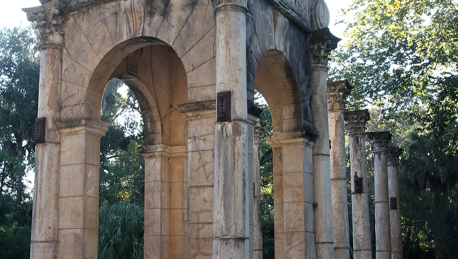
Calle Grande Arches
Calle Grande Street west of US-1 (Ridgewood Avenue) in Holly Hill
Calle Grande Arches Image courtesy Daytona Beach News Journal
Dating to the mid-1920s, the remains of the Calle Grande Arches are a true site to behold.
William Collins Hardesty was the man behind a proposed development called Rio Vista on the Halifax. Plans called for cottages, a large hotel, a golf course, and a canal for gondola rides. Today, the Riviera Hotel remains from the original development, now as an assisted living facility. The golf course is part of the Riviera Country Club.
The still standing arches, which are located at what was to be the entrance to the grand project, are situated on the banks of a dirty canal. The detail put into these columns is incredible. Painted to look like marble they provide the feel of ancient Rome.
When visiting, please use extreme caution and park well off the road. Calle Grande Street is a known for drivers exceeding the speed limit. In the past, drivers have hit and damaged the columns. Visitors should pay attention to where they are walking when visiting the site. Take nothing but photos and do not touch the arches. The arches are not in the best of condition and can easily be damaged. Also, you don’t want to end up taking a header into the canal.
One final word of warning, I have been told that the homeless often congregate around this area. Deal with them at your own risk.
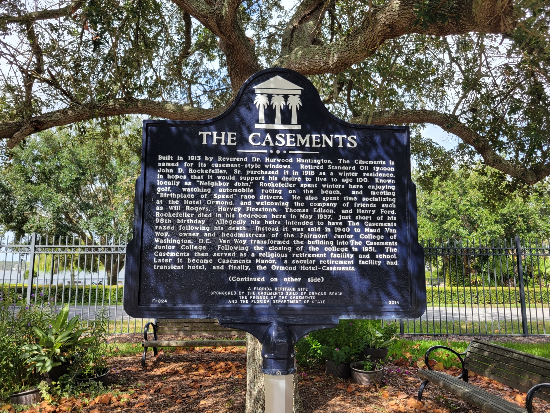
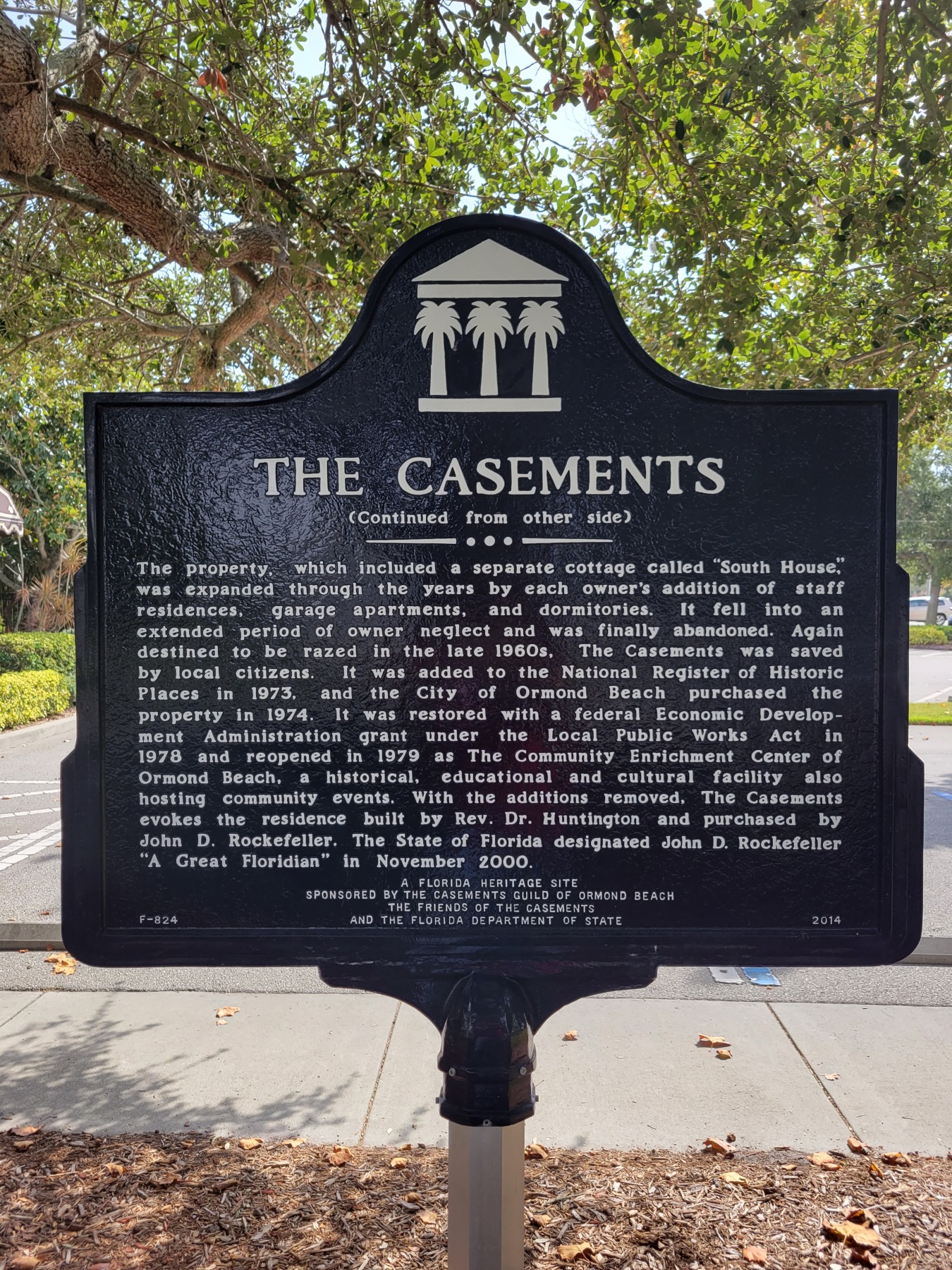
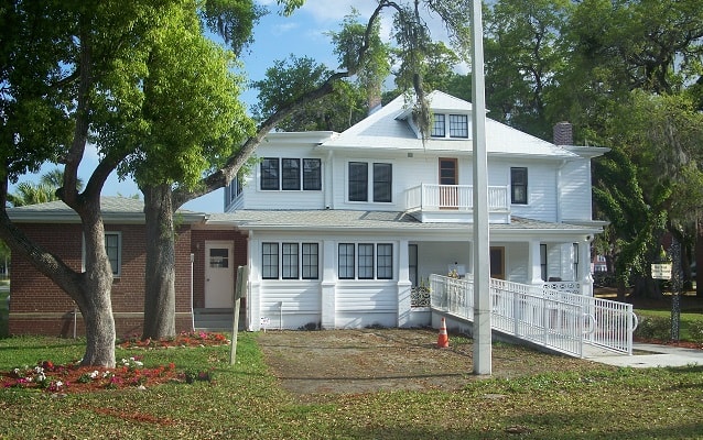
Located between the Halifax River and the Atlantic Ocean, the Casements was built in 1913 and was purchased in 1918 as the winter home of John D. Rockefeller.
The property was placed on the National Register of Historic Places in 1973. It was purchased by the city of Ormond Beach in 1974 with renovations completed in 1979.
The Casements is now a multi-use facility offering visitor tours, workshops, classes, and special event rentals. Be sure to see the Boy Scout and Hungarian folk exhibits located on the third floor. The annual Ormond Beach Celtic Festival is held close by.
On the grounds, be sure to seek out the small marker placed by the Society of American Travel Writers. Please read my post on this marker by using THIS LINK. There are also two identical two-sided state historic markers for The Casements.
The Casements, Florida Historic Marker Side 1The Casements, Florida Historic Marker Side 2
Founded in 1991, the 70-seat theater opened in 2010, providing an art house experience to visitors, showing first run independent, foreign, documentary, and art films that would not be available in Volusia County otherwise. This small theater fills a unique niche and has no comparable location in the county.
Ticket prices are around $10 per person. Limited food and drinks are available. Maybe stop in at Angell & Phelps for your movie snacks.
See the website for programming information and dates.
First opened in 1959, the “World Center of Racing” annually hosts some of the largest stock car events in NASCAR, including the season opening Daytona 500. Motorcycle races, concerts, vintage car shows, and an incredible, drive through, Christmas lights display are just a few of the things you’ll find throughout the year at the Speedway.
The speedway isn’t about racing only, however. The facility offers guided tours, the NASCAR Racing Experience, an incredible museum, shopping, and more. The One Daytona shopping center is across International Speedway Boulevard.
Be sure to take the self-guided tour outside the facility, including monuments and the NASCAR equivalent of the Hollywood Walk of Fame. See how your hands measure up against some of the greatest drivers in the world.
1000 Orange Avenue at Tuscawilla Park (be sure to take a stop at the World War I monument located close by.)
Two different courses are available allowing visitors to fit their schedule, ability, and budget to the attraction.
Test your skills on ladders, wooden bridges, tight rope cables, and zip lines.
Multiple pricing options are available. It’s about $55 to take both courses, plan on around 3 hours duration. Check their website for more information.
Who says there isn’t ice skating in Florida? The Tampa Bay Lightning have won two Stanley Cups in recent years and the Florida Panthers are a top hockey team also. Several minor league hockey teams call Florida home. Hockey is no longer a Canadian or northeast exclusive.
OK, so you aren’t ready for the NHL. How about a family friendly option instead? From public skating times, to skating and figure skating lessons, to hockey clinics, you can find it here in a clean and safe indoor environment.
601 Earl Street, located beach side, adjacent to the Ocean Center and the large parking garage. Nearby you will also find the Tourist Church, referenced below.
Located just a block from the beach, Daytona Lagoon has something for every member of the family: thrill slides, pools, go-karts, laser tag, arcade games, mini golf, a sky maze rope course, and more.
The waterpark is of course the main attraction here. It features several fun slides including Kraken’s Revenge, the Shaka Halfpipe, Blackbeard’s Revenge, and more. There is a lazy river, a lagoon pool, and a children’s play area for younger visitors. Life jackets and lifeguards are on site.
The best parking is in the County of Volusia parking garage located adjacent to the park. Parking costs $8 but bring your garage ticket and they will validate your visit and you will pay only $4 to park. That’s a great deal and your car stays cool in the heat of the day.
Visit the website for multiple ticket pricing options.
Open 9a-5p Friday, Saturday, and Sunday, this market, which opened in 1981, features over 1,000 booths and 600 vendors over many acres. From antiques to vegetables to cell phone cases to getting a tattoo, you can find it here. Parking, admission, and people watching are free.
For car enthusiasts, the first Saturday of the month features a Classic Car Cruise In.
Gnome Tree
1037 Riverside Drive in Holly Hill
Started in 2003 by a local couple, the original display of three gnomes at the base of a large oak tree has grown to several hundred gnomes who now “inhabit” the picturesque tree.
They even have a Facebook Page, The Gnomes of Holly Hill, Florida. Want more? There is a short, self published book available as well. Click THIS LINK to find it and purchase your own copy.
Located in the County of Volusia owned, Merchants Bank Building, the Halifax Historical Museum is home to hundreds of items of local interest including artifacts, photos, souvenirs, and family mementos. The bank building, which is on the National Register of Historic Places, is a site to see on its own.
Located next to Abraxas Books (see above). Afterwards, stop in at Stavro’s Pizza House located just two doors from the museum.
Parking is free. Museum admission is $10 for adults, under age 12 are free. Closed Sunday and Monday.
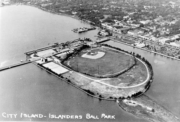
An overhead view of City Island Ballpark, now Jackie Robinson Ballpark close to how it looked when future Hall of Famer Jackie Robinson played there.
Originally opened in 1914 as City Island Ball Park, the present set up of field and seating dates to 1962. The field is currently home to the Bethune Cookman Wildcats baseball team and the Daytona Tortugas, the Cincinnati Reds low A farm team.
The ballpark is named after Hall of Fame player Jackie Robinson. It was in this stadium that he played his first spring training game in 1946. Stadiums in both Jacksonville and Sanford would not allow a mixed-race team to play on their fields and now Daytona Beach holds the honor of having hosted Robinson’s first game.
The ballpark was added to the National Register of Historic Places in 1998.
Learn about the history of Jackie Robinson Day and how it is celebrated in Major League Baseball at THIS LINK.
Golf lovers have a top-notch reason to visit Daytona Beach. The home course of the LPGA Tour, LPGA International features two, eighteen-hole courses designed by Arthur Hills and Rees Jones.
Also onsite are a three-hole practice course, chipping and putting areas, a driving range, Malcolm’s Bar and Grill, a pro shop, and member only facilities.
Visit the website to book a tee time or learn more about membership.
Looking to play golf around Volusia County? Take a look at my listing of golf courses in the county HERE.
Not to be confused with the Marine Discovery Center in New Smyrna Beach, the Marine Science Center, which opened in 2002, is operated by the County of Volusia.
From their website, this remarkable project has allowed Volusia County to stand at the forefront of county government efforts to educate our public about the marine resources of our area and to rehabilitate and release sea turtles and seabirds.
The site includes a nature trail, boardwalk, multiple exhibits, a touch pool that features several types of marine life including rays, and Turtle Terrace, where visitors can witness turtle rehabilitation in process.
In its twenty years of operation the facility has cared for more than 20,000 sea turtles and more than 18,000 birds in addition to hosting more than one million visitors.
Be sure to visit the Ponce Inlet Lighthouse if you visit here (see below for lighthouse information.)
Closed on Monday. Adult admission is $8, seniors $7, children ages 3-12 are $5.
Mary McLeod Bethune home. Image courtesy National Park Service
640 Dr. Mary McLeod Bethune Boulevard
The home was built in 1905 and purchased for Dr. Bethune in 1913 and served as her primary residence until her death in 1955.
The home appears to be temporarily closed for tours. When it reopens guided tours from Foundation employees and student workers are free, but donations are accepted. I took a tour a couple of years ago and the student giving the tour was knowledgeable, friendly, and quite accommodating to our group.
The home was dedicated as a National Historic Landmark in 1975.
MOAS features many permanent, rotating, and traveling exhibits.
The Charles and Linda Williams Children’s Museum is a favorite for families. Also, a family favorite are the Root Family Museum exhibits including Coca-Cola memorabilia, a train station including two mid-century cars, a collection of teddy bears, and more. Every child will want to see the thirteen-foot-tall giant ground sloth fossil in the Prehistory of Florida gallery.
For adults, the Cuban collection is world renowned. African tribal objects, arms and armor, the gallery of American art, decorative arts, and Chinese art are available. The planetarium will be a hit with both adults and children in your group.
The Cici and Hyatt Brown Museum of Artfeatures perhaps the greatest collection of Florida art in the world. At more than 2,600 pieces the museum does a great job or rotating exhibits.
The museum is open seven days a week. A ticket combination package for MOAS and the Brown Museum is under $20 for adults. Separate pricing is available. A great bargain for art and history enthusiasts. This is without question one of the best museums in the state.
If you only have time for one activity, this is the one I recommend!
The Ocean Center is located adjacent to Daytona Lagoon and Peabody Auditorium and only a couple blocks from the Tourist Church. There is a parking garage across the street. The Ocean Center has parking on site but there is sometimes a charge, particularly if events are going on.
Conveniently located directly across from the World’s Most Famous Beach, the Ocean Center features an arena that can hold 9,000 people, an exhibit hall with over 93,000 square feet of space, and multiple conference and breakout rooms.
I have included the Ocean Center because it features a large public art collection that may be viewed during open hours. Also on site is the ECHO Gallery, an area of rotating exhibits featuring the ECHO themes; environmental, cultural, heritage, outdoor.
Be sure to take a virtual tour on the facility website.
Image courtesy Ormond Memorial Art Museum & Gardens
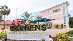
Just as World War II came to an end, one artist with a vision, and the people of Ormond Beach, worked together to create something magical.
Artist Malcolm Fraser offered a collection of his life’s work to any town along the east coast of Florida that would create an art museum that paid tribute to veterans. Ormond Beach and her residents rose to the occasion and worked together to create a living monument to creative freedom and equality of all persons, and to commemorate the service of World War I & II veterans who fought valiantly for that ideal.
Today, the newly remodeled and expanded museum offers permanent exhibits, traveling shows, virtual exhibits, and courses of all type.
The Gardens offer native and exotic plants and provide a perfect backdrop for weddings and other celebrations. While touring the Gardens be sure to seek out the military plaques and sculptures.
Open Monday through Friday 10a-4p and weekends noon to four. Admission is free but a $2 donation is recommended. This is one of the best values an art lover will find.
Main Street across from the Boothill Saloon. The Boothill itself can be quite the destination if you are so inclined. As the saying goes, “Come on in and grab a seat. You’re better off here than across the street.”
Pinewood Cemetery, also known as Peninsula Cemetery, dates to the late 1880s, and contains the final resting spots for many of Daytona Beach’s earliest pioneers including names such as Day, Burgoyne, and Jackson. Military headstones indicate burials of men who fought in several different wars are interred her.
Cemetery hours look to be Monday through Saturday, 8 am-5 pm; closed on Sunday. The walk through the cemetery can be uneven so dress appropriately.
Hawaiian Inn Beach Resort 2301 S. Atlantic Avenue in Daytona Beach Shores
An authentic interactive luau experience featuring hula dancing, flaming knife dancing, and more. Suitable for all ages. Includes an all you can eat tropical meal with dishes such as teriyaki chicken, kalua pork, Hawaiian pizza, multiple side dish options, Pepsi products, and a cash bar.
Current show times are at 6:00 p.m. on Tuesday through Saturday. Make your reservations through the website. Tickets look to be about $50 for adults.
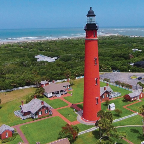
Image courtesy Ponce Inlet Lighthouse. 30 Best Things to do in Daytona Beach, Florida.
4931 S. Peninsula Drive in Ponce Inlet
Step back in time and climb 175 feet of fun in the Florida sun at the Ponce Inlet Light Station and Museum! Constructed in 1887, the Ponce de Leon Inlet Lighthouse has guided mariners along the Florida coast for more than 130 years.
Admission is about $7 for adults, with several discount programs available. Climb all 203 steps to the top if you dare. Remember, you have to come back down also. The views are worth it!
Be sure to visit the Marine Science Center if you are at the lighthouse. See the information above.
The lighthouse was declared a National Historic Landmark in 1998
Also known as Dunlawton Sugar Mill Gardens, the property is operated by a not-for-profit corporation and owned by the County of Volusia. Entrance is free and donations are appreciated. Donations benefit the not-for-profit organization and help them with park upkeep.
The property contains dozens of gardens and plants, but the real star of the show is the remains of a 19th century sugar factory that were part of the Dunlawton Plantation. Multiple interpretive panels will guide you through the history of the land and the artifacts you will find onsite. Don’t be surprised if you see a dinosaur or two while you are on the park grounds!
You will often find volunteers onsite who can provide information on the plants and flowers.
1200 W. International Speedway Boulevard (on the Daytona State College campus)
One of several excellent art museums in the Daytona area, the Southeast Museum of Photography exhibits, collects, preserves, and interprets photography to facilitate teaching and learning at Daytona State College and enhances the community’s understanding of, and appreciation of culture, history, and photography.
Check the website for current exhibits, dates, times, and special events.
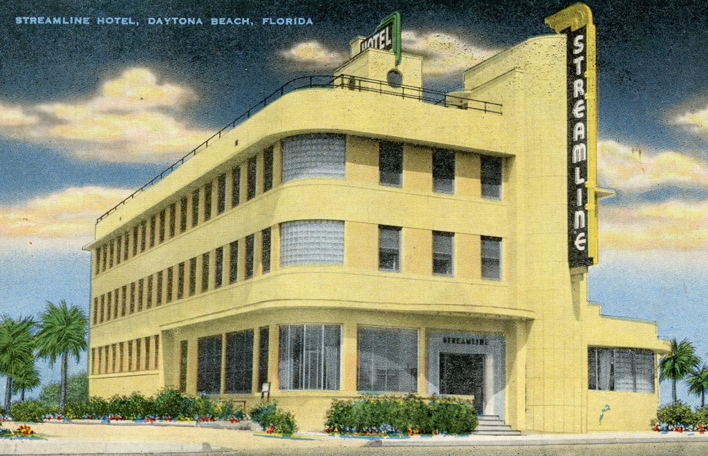
Opened in 1940, this is the hotel where NASCAR was born! Once a dilapidated flophouse, the now fully renovated boutique hotel once served as local headquarters for the Women’s Auxiliary Corp during World War II.
Located directly across from the beach, the rooftop bar offers incredible views, or have dinner at the Victory Lane restaurant.
Tomoka is a bird-watcher’s paradise, with over 160 species sighted, especially during the spring and fall migrations. Visitors can stroll a half-mile nature trail through a hardwood hammock that was once an indigo field for an 18th-century British landowner.
The park protects a variety of wildlife habitats and endangered species such as the West Indian manatee. For many visitors however, Chief Tomokie is a highlight of the park.
A boat ramp gives boaters and canoeists access to the river. The park store offers snacks, camping supplies, and canoe rentals.
For overnight stays, the park has full-facility campsites and youth camping.
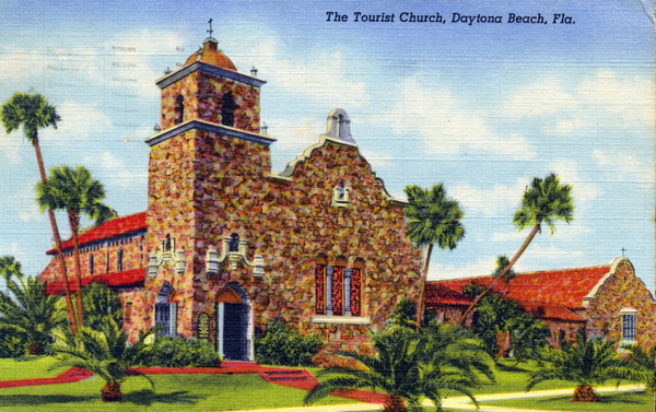
The Tourist Church, also known as the Seabreeze United Church of Christ and the First Congregational Church, is an historic church located at 501 North Wild Olive Avenue in Daytona Beach, Florida, United States. Built in 1929, it was designed by architect Harry Griffin in the Mission Revival Style of architecture. Today it is an active United Church of Christ congregation.
On October 6, 1995, it was added to the National Register of Historic Places.
You need to see this church to understand just how interesting it is. From the coquina to the stained glass. It’s worth the stop especially if you are visiting the Ocean Center or Daytona Lagoon. They are very close to each other.
The Tourist Church as depicted in an early 20th century postcard.
I hope you have enjoyed the 30 best things to do in Daytona Beach, Florida and that it makes your visit a memorable one. Please let me know of your favorites or places I should add.
This post may contain affiliate links. If you click these links and make a purchase, I may receive a small commission. This commission does not affect any price that you pay. All views and opinions provided are my own and are never influenced by affiliate programs or sponsors providing products.
If you are visiting Daytona Beach, make the short drive to Sanford and visit the Central Florida Zoo. Click this link or the image for your “skip the line” tickets.
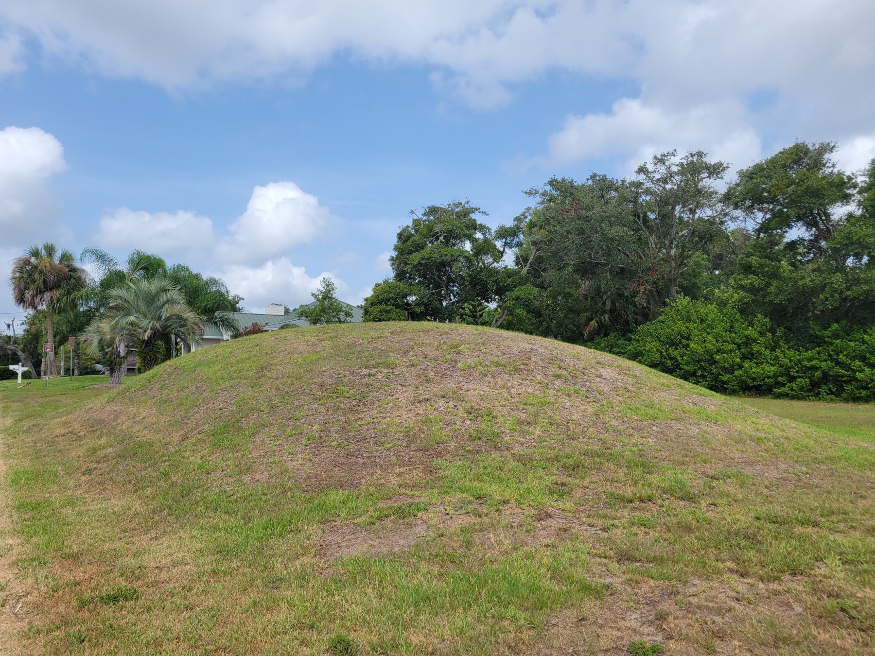
In May 1982, when Dixon H. Reeves, and his wife Harriett, paid contractors to break ground on a house site at the corner of south Beach Street and Mound Avenue in Ormond Beach, they did not fully comprehend the damage they were going to do to an irreplaceable cultural artifact. In fact, once the city manager issued a stop work order, the Reeves sued the city for damages. The property ownership reverted to Mr. and Mrs. Melvin Barron, who the Reeves purchased the property from, and the Reeves eventually received a $4,000 settlement from the city.
Ormond Indian Burial Mound
Where the Reeves wish to build their home was the site of a Timucuan Burial Mound. Timucuan society did not bury the dead. Instead the Timucuans placed bodies on top of the ground and piled dirt on top. In some instances, the flesh was allowed to decay, and the bones were bundled and placed at the mound site. Items owned by the deceased were broken and included in the interment.
Despite the mound having received considerable damage through the years, including digging by “pot hunters” and construction of adjacent roadways, archaeologists believe as many as 125 Timucuans had been buried on the site. For anybody caught digging on this, or similar sites, you will more likely than not be charged with a third-degree felony. See this link for additional information.
With a lack of consensus among city leaders, a fund was started to help purchase and preserve this sacred site. The Barron’s agreed to sell the property to the city for $55,000. Despite confirmation on the importance of the site from professional anthropologists and archaeologists, it took an anonymous donation of $30,000, along with the fundraising drive, to help secure the sale as shortsighted elected city officials balked at the price and potential ongoing costs.
Today, the City of Ormond Beach owns this site and is a park in a residential area. Visitors can see the mound from all sides, surrounded by roads and houses. Parking is available across the street at Ames Park so please do not park on park lands or in the yards or drives of nearby property owners. Please do not climb on the mound as it is a fragile archaeological site.
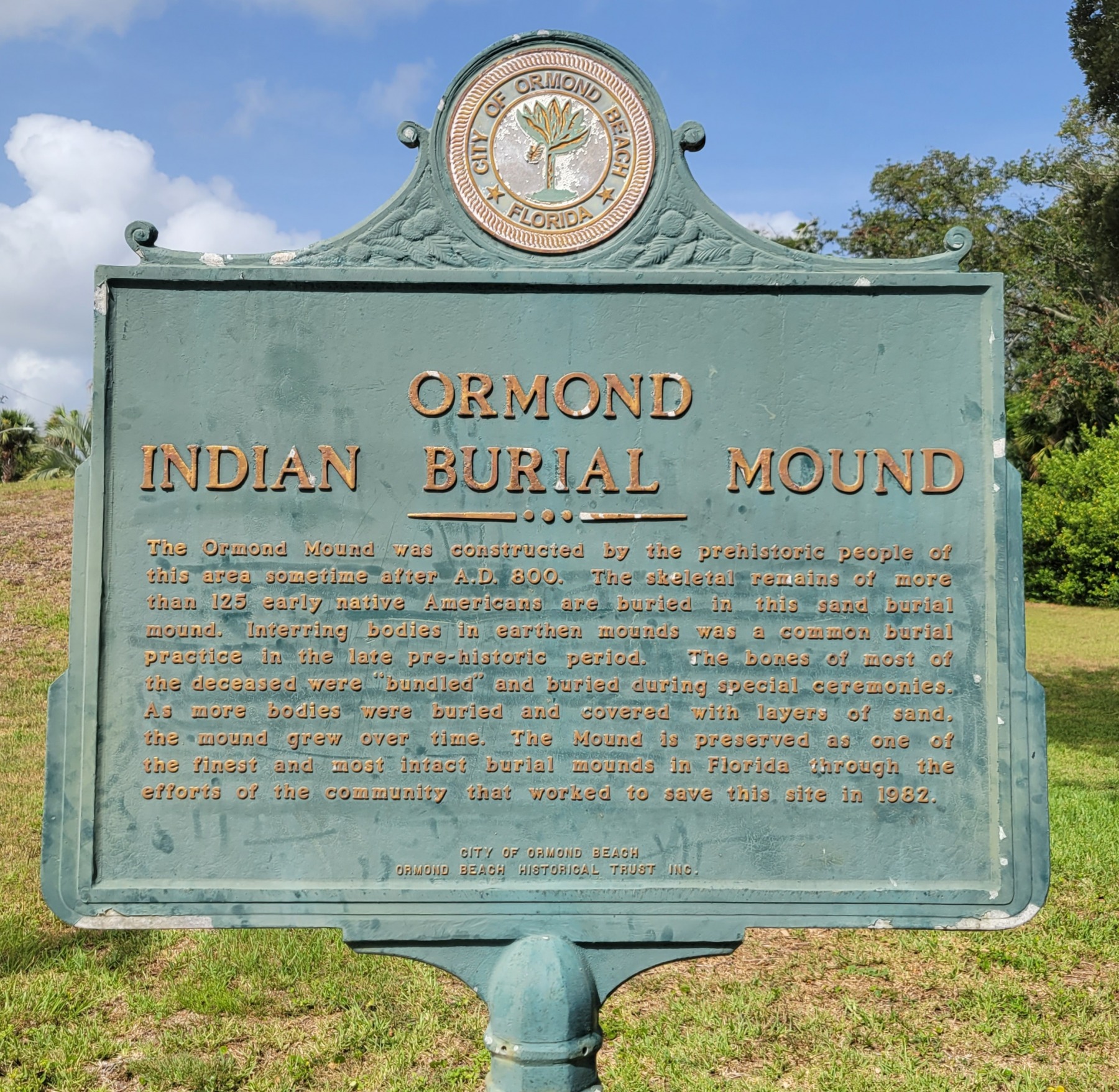
Sign Text
Ormond Indian Burial Mound Historic Marker placed by the City of Ormond Beach and the Ormond Beach Historical Trust
Prehistoric people of this area constructed the Ormond Burial Mound sometime after A.D. 800. The skeletal remains of more than 125 early native (sic) Americans are buried in this sand burial mound. Interring bodies in earthen mounds was a common burial practice in the late pre-historic period. The bones of most of the deceased were “bundled” and buried during special ceremonies. As more bodies were buried and covered with layers of sand, the mound grew over time. The Mound is preserved as one of the finest and most intact burial mounds in Florida through the efforts of the community that worked to save this site in 1982.
City of Ormond Beach
Ormond Beach Historical Trust
The City of Ormond Beach placed this marker and is not a part of the Florida Department of State marker program.
If you wish to learn more about Timucuan culture there is an excellent book I can recommend.
Perhaps the definitive book on the subject is written by Dr. Jerald Milanich, The Timucua.
This is the story of the Timucua, an American Indian people who thrived for centuries in the southeast portion of what is now the United States of America.
Timucua groups lived in Northern Florida and Southern Georgia, a region occupied by native people for thirteen millennia. They were among the first of the American Indians to come in contact with Europeans, when the Spaniard Juan Ponce de Leon landed on the Florida coast in 1513. Thousands of archaeological sites, village middens and sand and shell mounds still dot the landscape, offering mute testimony to the former presence of the Timucua and their ancestors.
Two hundred and fifty years after Ponce de Leon’s voyage the Timucua had disappeared, extinguished by the ravages of colonialism. Who were the Timucua? Where did they come from? How did they live? What caused their extinction? These are questions this book attempts to answer, using information gathered from archaeological excavations and from the interpretation of historical documents left behind by the European powers, mainly Spain and France, who sought to colonize Florida and to place the Timucua under their sway.
Bry, Theodor de, 1528-1598. XXIV. Mode of Drying Fish, Wild Animals, and other Provisions. 1591. State Archives of Florida, Florida Memory. Accessed 22 October 2022.
The State Library and Archives of Florida (Florida Memory), has an excellent page of Theodor de Bry’s Engravings of the Timucua. These incredible works of art date from before the year 1600. The 42 pieces are all available for viewing and low resolution copies are available for download. A sample de Bry image is seen at the left.
Sources:
Daytona Beach News Journal
Florida Master Site File VO00240
Ormond Beach Historical Trust, Inc. “The Story of the Timucua Indian Burial Mound in Ormond Beach, Florida.” Pamphlet published April 2000.
Click the image to support this site through Buy Me A Coffee. Your support pays for web services, research trips, photocopies, and photo usage fees.
This post may contain affiliate links. If you click these links and make a purchase, I may receive a small commission. This commission does not affect any price that you pay. Affiliate programs or sponsors providing products do not influence the views and opinions shared on this website.
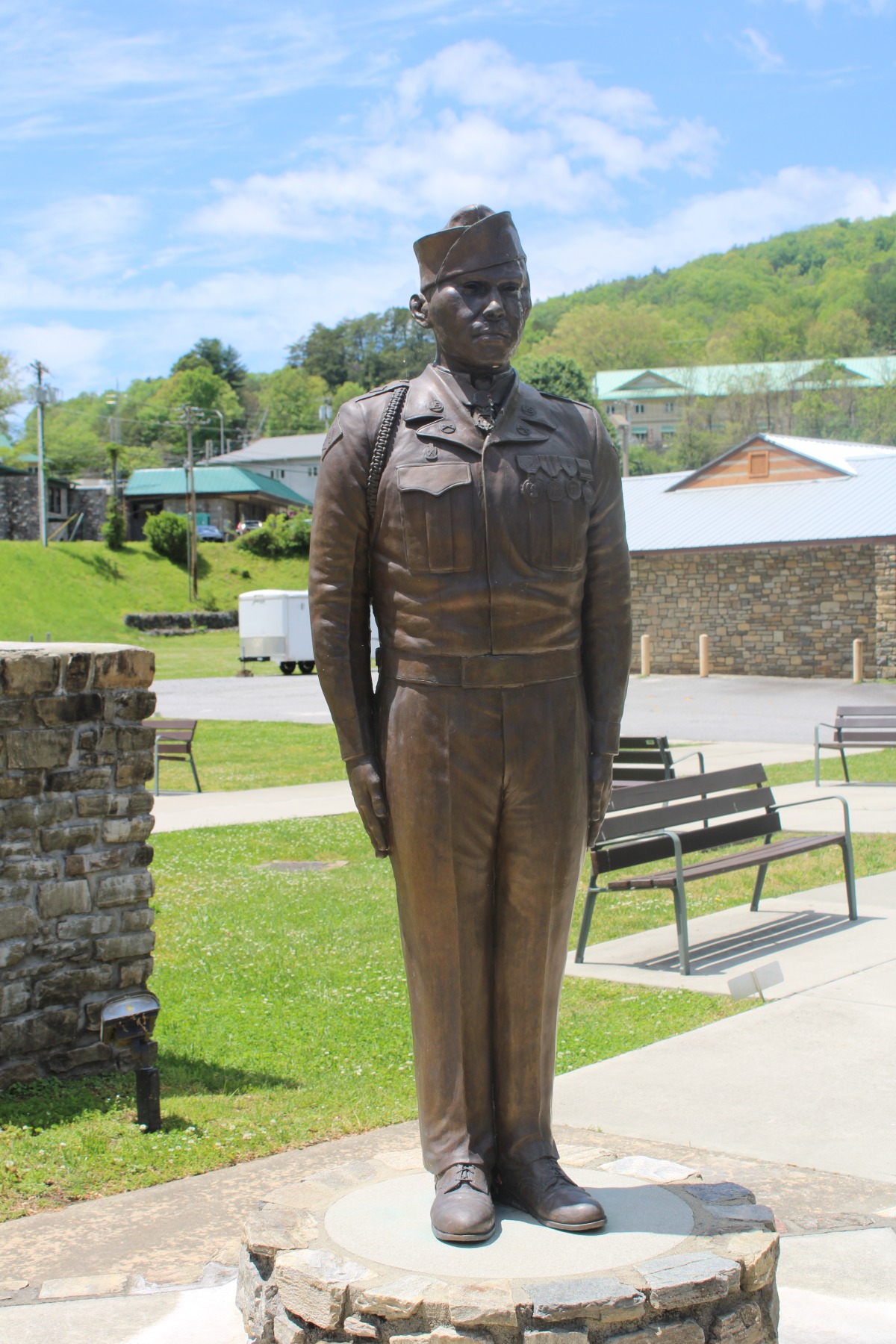
Tsali “Charles” George was born August 23, 1932 in Cherokee, North Carolina as a member of
the Eastern Band of the Cherokee Tribe. Charlie, as he was known, attended the Indian School
on the Qualla Boundary of Western North Carolina and spent much of his early life near the
Oconaluftee River.
Charles George Image Courtesy North Carolina Department of Natural and Cultural Resources
At age 18, with the Korean War in full force, Charlie joined the United States Army in Whittier, North Carolina, attaining the rank of Private First Class. He served in Company C of the 179th Infantry Regiment, 45th Infantry Division.
In November 1952, PFC George gave his life in order to protect that of fellow soldiers, Armando Ruiz and Marion Santo, who along with George were helping lead an assault to try to capture a prisoner for interrogation, just north of Seoul during the Battle of Songnae-dong. Having succeeded in their mission George, Ruiz, and Santo were ordered to provide cover as the Company retired.
The Chinese were continuing to fight and a grenade landed near the three young men. George pushed Santo away before falling on the live grenade in order to prevent injury and possible death to others. Despite his life threatening injuries George did not utter a sound. To do so would have betrayed their location to the Chinese.
Ruiz and Santo bravely carried the dying George to the nearest aid station but the wounds were too severe and the heroic young Cherokee passed. Both Armando Ruiz and Marion Santo survived the war, returning to the States and leading as normal a life as possible having witnessed the ultimate horror of war.
While in Cherokee County, be sure to make your way over to Murphy. While there you don’t want to miss the Hunter Pyramid.
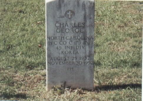
Charles George headstone at Yellow Hill Veterans Cemetery. Image courtesy Findagrave.
The body of Charles George was returned to Cherokee County where he was interred in Yellow Hill Cemetery. You may view an online memorial to PFC George here.
PFC George’s heroics were recognized quickly and in March 1954, George’s parents were invited to Washington D.C. in order to receive the Medal of Honor being awarded posthumously to their son. In the following years, Charlies father, Jacob, was known to carry the Medal with him, keeping this piece of his son close to him at all times.
In recent years, further honors have been bestowed upon the memory of PFC Charlie George.
The Department of Veterans Affairs Medical Center in Asheville, NC was renamed the Charles George Department of Veterans Affairs Medical Centerin 2017 after approval by both the
United States House of Representatives and the Senate.
The bridge crossing the Oconaluftee River in the Yellowhill Community was dedicated as the
Charles George Bridge on January 23, 2014.
The Charles George Monument located in the Cherokee Veterans Park. An identical monument sits at the VA Center named in his honor.
On September 24, 2016, a life-sized statue of George, sculpted by artists James Spratt, was unveiled at the Charles George VA Medical Center. Center Director Cynthia Breyfogle stated, “The legacy of Charles George was, and still is, an inspiration and influence beyond his local community. His courage and example join those of other brave men and women, past and present, who have answered the call when their country needed them.”
Unfortunately, Mr. Spratt did not live to see the unveiling. He passed away the day of the unveiling while under hospice care. Warren Dupree of the American Legion Post 143 said a few words on behalf of Spratt, “…he wanted to thank the Eastern Band of Cherokee Indians and the Charles George Memorial Project Committee for their kindness in helping him make his dream come true.”
On November 11, 2016, an identical sculpture to the one located at the VA Center was unveiled in a moving ceremony at the refurbished Cherokee Veterans Park.
The Museum of the Cherokee Indian opened an exhibit in George’s honor on Memorial Day, May 28, 2018. The impressive displays included a bronze bust of George, the flag that draped his coffin, his numerous military medals including his Medal of Honor, and a copy of the text of his Medal of Honor citation. You may read this citation below.
Citation:
Pfc. George, a member of Company C, distinguished himself by conspicuous gallantry and outstanding courage above and beyond the call of duty in action against the enemy on the night of 30 November 1952. He was a member of a raiding party committed to engage the enemy and capture a prisoner for interrogation. Forging up the rugged slope of the key terrain feature, the group was subjected to intense mortar and machine-gun fire and suffered several casualties. Throughout the advance, he fought valiantly and, upon reaching the crest of the hill, leaped into the trenches and closed with the enemy in hand-to-hand combat. When friendly troops were ordered to move back upon completion of the assignment, he and two comrades remained to cover the withdrawal. While in the process of leaving the trenches a hostile soldier hurled a grenade into their midst. Pfc. George shouted a warning to one comrade, pushed the other soldier out of danger, and, with full knowledge of the consequences, unhesitatingly threw himself upon the grenade, absorbing the full blast of the explosion. Although seriously wounded in this display of valor, he refrained from any outcry which would divulge the position of his companions. The two soldiers evacuated him to the forward aid station and shortly thereafter he succumbed to his wound. Pfc. George’s indomitable courage, consummate devotion to duty, and willing self-sacrifice reflect the highest credit upon himself and uphold the finest traditions of the military service.
This post may contain affiliate links. If you click these links and make a purchase, I may receive a small commission. This commission does not affect any price that you pay. All views and opinions provided are my own and are never influenced by affiliate programs or sponsors providing products.
Are you visiting the Great Smoky Mountains area? Click THIS LINK or the image above for great ticket and tour opportunities.
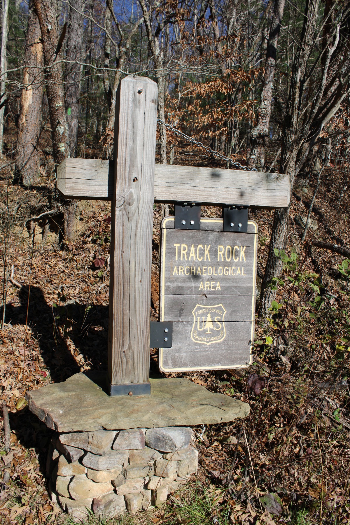
Visitors to the Chattahoochee-Oconee National Forests near Blairsville, Georgia, have a unique opportunity to view a large collection of petroglyphs.
The sign indicating the Track Rock Archaeological Area where you can visit the petroglyphs.
What is a petroglyph?
Track Rock Information Panel
The first question a reader may have is, just what a petroglyph is. According to the National Park Service “Petroglyphs are rock carvings (rock paintings are called pictographs) made by pecking directly on the rock surface using a stone chisel and a hammerstone.”
How old are they?
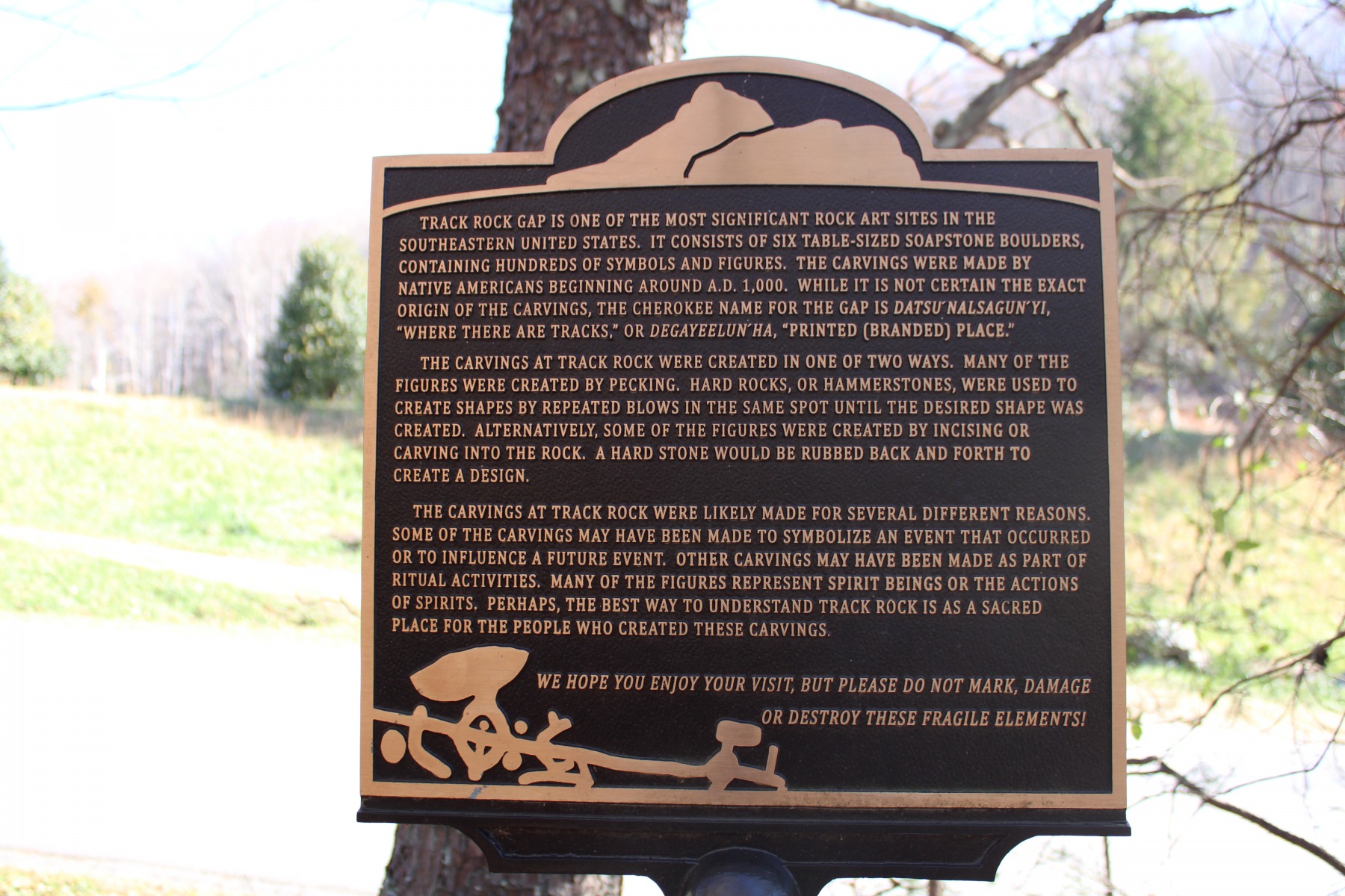
Track Rock Gap is located between Thunderstruck Mountain and Buzzard Roost Ridge near the
town of Blairsville in Union County, Georgia. Here, more than 1,000 years ago, Creek and
Cherokee peoples created the soapstone carvings we now enjoy today.
Considered one of the most significant rock art sites in the Southeastern United States, Track
Rock features a diverse grouping of more than 100 figures.
What do they mean?
A legend to some of the markings found on the petroglyphs.
Archaeologists do not believe Track Rock to have had a singular purpose or to have been carved in a singular period; rather, the carvings were made over time and for differing reasons. Some of them may symbolize or commemorate a particular event that happened. Others may have to do with rituals and ceremonies. As the National Park Service states
Furthermore, the setting of Track Rock in a gap places it at a threshold. In numerous Cherokee stories, footprints and tracks signify an in-between or transitional state or condition. More specifically, rocks with footprints and tracks signified the area of transition, a doorway or threshold, into the domain of dangerous spirit beings.
Depictions of footprints and tracks are not only physical testimony that spirit beings were there some time in the past, but that they could still be lingering somewhere close-by in the present, and that they may return unexpectedly at any time in the future.
How do I visit?
You can easily visit this amazing archaeological site. There is no entry or parking fee charged.
You can reach Track Rock Gap by taking US 129 to Blairsville, then US 76 east about five
miles. At the signs for Track Rock Gap Road, turn right for about two miles to the gap. Their
location in the gap makes stopping beside the boulders very dangerous.
Drive on through the gap, noting the Track Rocks on the right, and look for the small parking lot
on your right. Park there and take the trail back to the gap, safely from traffic. The trail is not
long or strenuous but it is through a wooded area so proper footwear is suggested. The path can
be slippery depending upon weather conditions.
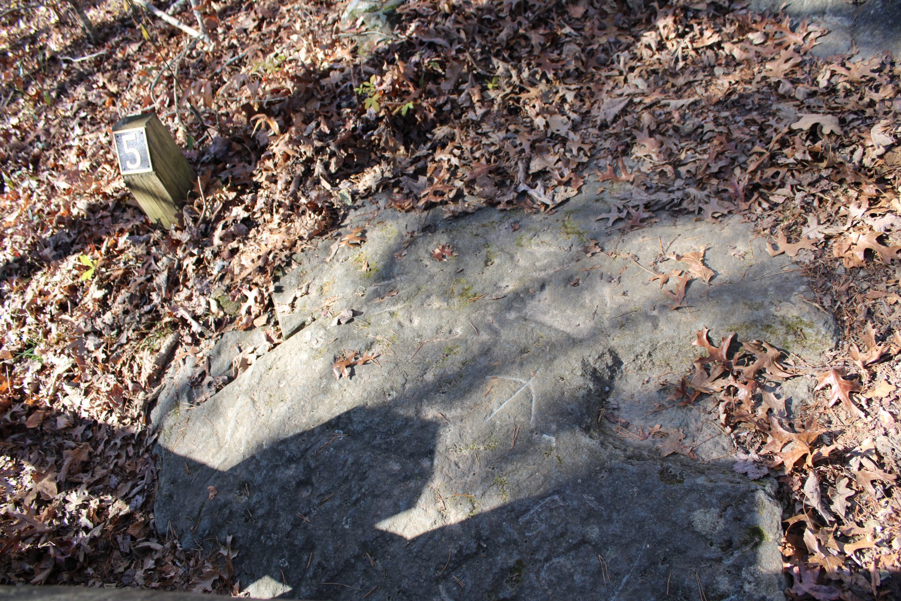
While not photographed at the best lighting, carvings are still visible in this rock.
The NPS suggests visiting when sunlight is at a low angle. Consider visiting either early morning or late in the day. Brighter sunlight makes viewing the petroglyphs more difficult. If you click the link below to learn more about the site there are convenient fact and description sheets available to help you navigate the site.
Remember, leave nothing but footprints and take nothing but photos. Let’s make sure this sacred site is available for the next thousand years.
How can I learn more?
To learn more about the petroglyphs visit the forest service sitehere.
Learn more about the Archaeological Resources Protection Act (ARPA) by visiting the National Park Service pagehere.
You can learn more on the subject by reading the account “An Archaeological and
Ethnohistorical Appraisal of a Piled Stone feature Complex in the Mountains of North Georgia”
published in the journal Early Georgia (Vol. 38, No. 1, p. 29-50) in 2010 by archaeologists
Johannes Loubser and Douglas Frink. Check with your local librarian to see if any of their
databases carry this journal.
This post may contain affiliate links. If you click these links and make a purchase, I may receive a small commission. This commission does not affect any price that you pay. All views and opinions provided are my own and are never influenced by affiliate programs or sponsors providing products.
Are you interested in hiking in the Chattahoochee National Forest? This map pack from National Geographic is a must have.
National Geographic’s Chattahoochee Bundle Pack combines two Trails Illustrated titles for Chattahoochee National Forest. Located just north of Atlanta, the Chattahoochee National Forest contains the southern terminus of the Appalachian Trail along with an abundance of recreational opportunities for outdoor enthusiasts of all interests. The maps’ highlights are: Southern Terminus of the Appalachian Trail, Russell-Brasstown Scenic Byway, Cohutta, Raven Cliffs and Rich Mountain Wilderness Areas, White Rock Scenic Area, Brasstown, Ellicot Rock, Southern Nantahala, Tray Mountain, Raven Cliffs Wilderness Areas, and Chattooga Wild and Scenic River.
Click the photo or this link for more information on purchasing the map.
 Text
Text The second, referenced above, lasted from 1835 until 1842. Because of its length and bloodiness, some historians call the Second Seminole War, The Seminole War. At the conclusion of hostilities, the United States Army transported more than 4,000 Seminoles west. I refer readers to the excellent book written by John K. Mahon titled History of the Second Seminole War: 1835-1842.
 Tomokie Today